Step 3
Review the Suggested DEM Bounds.
Redem uses the marker locations to determine what Rail Simulator tiles they fall in. ReDem will create all those terrain tiles as well as extra tiles beyond those with markers. The number of extra tiles is set by the Range Numeric Up-Down Box in the Suggested DEM Bounds Panel. A Range of 2 would cause 2 additional tiles to be created to the East, West, North, and South of each tile containing a marker.
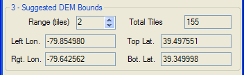
As the Range is changed ReDem calculates the DEM needed to cover all the requested tiles and displays the left and right longitude and the top and bottom latitude needed to cover the area of interest. The Total Tiles that would be created is also shown. As the Range is increased ReDem needs to make many more calculations, there can be a delay between updates to the Total Tiles value.
Use the Left, Right, Top, and Bottom values from the Suggested DEM Bounds panel to specify the download area when you download a BIL file from the USGS Seamless Server. A brief tutorial on downloading a BIL file can be found in the Addendum.
Note: You don't have to download the entire Suggested DEM bounds. You can download pieces of the suggested area and create tiles for those pieces individually. As long as the route start is the same the output tiles will match any tiles created earlier.
Unzip the downloaded Dem into a convenient folder.
(C) 2009 ZugWare