Step 2
Load Markers.
Click on the Load Button in the 2 - Markers Panel to open a file selection dialog and select the maker file you wish to use. ReDem can read MSTS *.mkr, RS *.csv, and USAPhotoMaps route files.
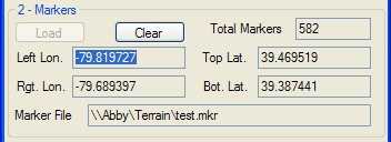
ReDem will determine the most northern (top) and southern (bottom) latitude, and the most western (left) and eastern (right) longitude of the markers.
The longitude and latitude of the maximum and minimum marker values, the number of markers, and the marker file read will be displayed in the fields in the 2 - Markers Panel. You may clear the marker set by clicking on the Clear Button in the 2 - Markers Panel.
(C) 2009 ZugWare